Shannon Murphy, Holly Twamley, Sophie Phillips and Cathal Dreelan from Buncoldy, Wexford, splashing through the puddles at Ploughing 2017. \ Ramona Farrelly
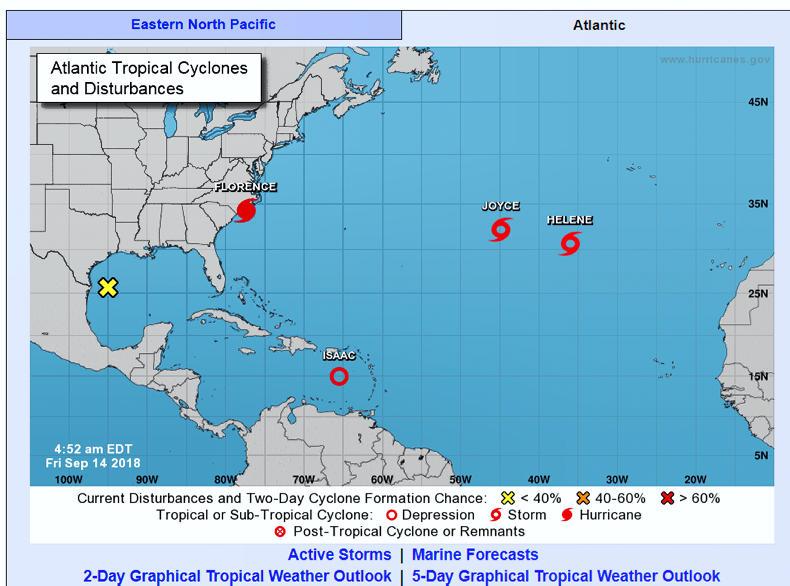
Tropical Storm Helene will take a northeastward track towards our shores early next week. It is currently transitioning to an extra-tropical cyclone southwest of the Azores Islands, which is where Hurricane Ophelia started out. This means that Helene will lose it’s tropical characteristics and become more akin to the low-pressure systems we are used to seeing in our part of the world.
The exact track of the storm remains unclear, but the European weather model has it tracking into the Irish Sea, with the strongest of winds staying offshore. The US weather model has it tracking directly over Ireland. This uncertainty on the details will continue for days.
The current forecast is that Helene will be to the south of Ireland on Monday night. The low-pressure system will move northeastwards up through the Irish Sea overnight Monday and early on Tuesday. The exact path is still uncertain. Met Eireann says that a humid spell of wet and windy weather is expected to sweep up over Ireland on Monday night and early Tuesday as a result. There will potentially be warnings for wind and rain issued for day one of the Ploughing.
Hurricane season
While Helene is the only tropical storm Ireland needs to worry about, the Atlantic hurricane season is at its peak and there are a number of tropical storms at large at the moment.
Graphic from the National Hurricane Centre.
Current advisories in force from the National Hurricane Centre include:
Hurricane Florence on the North Carolina coast, which is forecasted to continue to move slowly inland over the continental United States.
This content is available to digital subscribers and loyalty code users only. Sign in to your account, use the code or subscribe to get unlimited access.
The reader loyalty code gives you full access to the site from when you enter it until the following Wednesday at 9pm. Find your unique code on the back page of Irish Country Living every week.
CODE ACCEPTED
You have full access to the site until next Wednesday at 9pm.
CODE NOT VALID
Please try again or contact support.
Tropical Storm Helene will take a northeastward track towards our shores early next week. It is currently transitioning to an extra-tropical cyclone southwest of the Azores Islands, which is where Hurricane Ophelia started out. This means that Helene will lose it’s tropical characteristics and become more akin to the low-pressure systems we are used to seeing in our part of the world.
The exact track of the storm remains unclear, but the European weather model has it tracking into the Irish Sea, with the strongest of winds staying offshore. The US weather model has it tracking directly over Ireland. This uncertainty on the details will continue for days.
The current forecast is that Helene will be to the south of Ireland on Monday night. The low-pressure system will move northeastwards up through the Irish Sea overnight Monday and early on Tuesday. The exact path is still uncertain. Met Eireann says that a humid spell of wet and windy weather is expected to sweep up over Ireland on Monday night and early Tuesday as a result. There will potentially be warnings for wind and rain issued for day one of the Ploughing.
Hurricane season
While Helene is the only tropical storm Ireland needs to worry about, the Atlantic hurricane season is at its peak and there are a number of tropical storms at large at the moment.
Graphic from the National Hurricane Centre.
Current advisories in force from the National Hurricane Centre include:
Hurricane Florence on the North Carolina coast, which is forecasted to continue to move slowly inland over the continental United States.
If you would like to speak to a member of our team, please call us on 01-4199525.
Link sent to your email address
We have sent an email to your address. Please click on the link in this email to reset your password. If you can't find it in your inbox, please check your spam folder. If you can't find the email, please call us on 01-4199525.
ENTER YOUR LOYALTY CODE:
The reader loyalty code gives you full access to the site from when you enter it until the following Wednesday at 9pm. Find your unique code on the back page of Irish Country Living every week.


SHARING OPTIONS