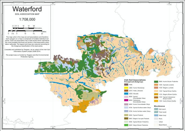
Co Waterford is home to the Copper Coast, which is a stretch of the southern coast of Ireland so named for its historic metal-mining industry. The diverse geology found in this area includes records of the last ice age and this area is a recognised UNESCO Global Geopark since 2004.
In terms of topography, the county has two main regions. Firstly, the upland region, which is situated in the west and includes the Comeragh and the Knockmealdown Mountain ranges. These mountain ranges are comprised of sandstone bedrock and sedimentary glacial drift.
The soils here reflect the typical soil sequence associated with a mountain scape – podzols (acidic nutrient poor soils) and peat at the highest altitude with brown podzolics (slightly acidic free-draining) further downslope and with surface-water gleys (slowly permeable sub-surface layer) on the lower slopes.
Secondly, the eastern region, where the relief is less prominent and the landscape is better described as undulating hills, comprised of shale and slate. This is accompanied with sedimentary glacial drift in the northeast and with igneous glacial drift in the southeast.
The soils associated with this landscape tend to be well-drained. However, groundwater-gleys may be found in depressions associated with a perched water table.
The county has two major river catchments – the Suir and the Blackwater – that provide natural drainage in the county.
The Suir drains a lot of the northeast region and provides a natural county boundary for much of the north and the east. The Blackwater drains much of the northwest and southwest regions. Brown earths are the most commonly found soil types found in Co Waterford, the most extensively found being the ‘Kill’ series (found in association 1100m led by subgroup 1100).
Although quite prevalent across the county, these soils are readily found in the area between Waterford City and Dungarvan and the coast. These are well-drained soils with a silt-loam texture.
The favourable climate in this county and the high water content means that these soils are suited to grass production, showing some of the highest grass yields in the country. Moreover, the free-draining nature of these soils means that they are at a low risk of poaching, so the potential grass utilisation is high.
The second most prevalent soil types are brown podzolic soils. The majority of the brown podzolics in Waterford are ‘Cupidstown Hill’ series (found in association 0900h led by subgroup 0900). These soils tend to have an acid upper horizon and present evidence of leaching due to the altitude, higher rainfall and lower temperature.
This can result in an iron-pan, which gives rise to potential drainage or root penetration issues. These soils have a limited use-range in an unimproved state and are most suited to extensive grazing. However, these soils respond well to soil and nutrient amendments, which can extend the use-range.


SHARING OPTIONS