Planning a paddock system or road network on your farm is difficult when you are not sure of the exact field sizes or distance of road required. Often, this type of work is carried out by manually stepping the field or even giving an educated guess as to where a paddock fence should go or the amount of stone needed for a roadway.
In addition, some farmers have paddocks already installed and are not sure of the exact paddock size because existing farm maps only give the acreage of the entire field. This makes it difficult to gauge quantities of fertiliser or grass seed required on an individual paddock basis.
Thankfully, technology is available which is accessible to most farmers via a PC or smartphone that can help estimate areas or distances on your farm. In this article we have focused on one app with multiple functions that can help take the guesswork out of field measurements. At the moment apps will not enable you to expertly map a field, but they are a great help. There are companies that specialise in mapping farms that use GPS to pinpoint where a fence should be erected. These companies will have experience mapping farms and their use is justifiable for larger mapping jobs. But for small-scale work, apps such as the one featured can come in handy.

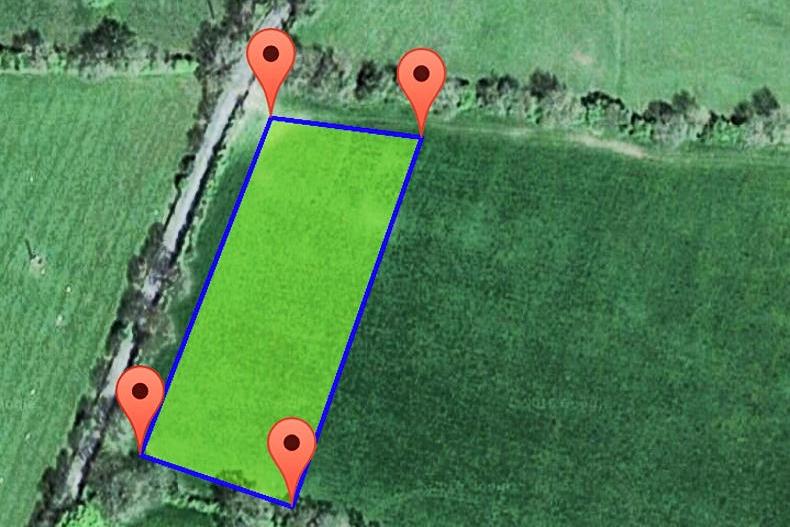
The Geomeasure Area Calculator is an app free to download for Android or Apple devices. The app has three main functions – to measure area, distance and elevation. Once you are comfortable using a smartphone, the app is easy to use. By default, it finds your current location, but this can be changed if needs be. To measure the area of a field or paddock, you find the map location you plan to work on and select the area option on the app. Tap anywhere on the map to place digital markers that create the perimeter of the area being mapped. Once you place all the markers on the boundaries of the selected area you will be able to see how many acres or hectares it encompasses.
Farmers who plan on using this app to improve the accuracy of erecting similar sized paddocks in a field can save maps on the app. This means maps can be used even if there is no internet connection in the field.
If you do not have a smartphone, there are websites that have similar functions of measuring area and distance. When you have mapped the areas on your computer you can print off the maps and areas for use in the field when new fences are being erected.

 The distance from one point in a map location on this app to another can be easily measured. Just select the distance option. Again, tap anywhere on the map to place the digital markers. When you are measuring a straight line just two markers are sufficient (picture two). Where the distance measured is following a meandering path, more markers should be applied to allow for the variability as in picture three.

Finally a useful function is the elevation tool. Some farmers are interested in this because it allows them analyse the falls on their land. If they were planning to carry out drainage work they could check to see the current levels on the farm. Elevations can be shown for a single marker or a combination. Picture four shows the height difference in feet between two points in a field.
Read more
What will farming be like in 10 years' time?
How automated body condition score can reduce feed bills
Autonomous tractors: are they the future?
Instant silage analysis
Will robots replace linear scorers?
Agri technology, helping to save lives around machinery
Planning a paddock system or road network on your farm is difficult when you are not sure of the exact field sizes or distance of road required. Often, this type of work is carried out by manually stepping the field or even giving an educated guess as to where a paddock fence should go or the amount of stone needed for a roadway.
In addition, some farmers have paddocks already installed and are not sure of the exact paddock size because existing farm maps only give the acreage of the entire field. This makes it difficult to gauge quantities of fertiliser or grass seed required on an individual paddock basis.
Thankfully, technology is available which is accessible to most farmers via a PC or smartphone that can help estimate areas or distances on your farm. In this article we have focused on one app with multiple functions that can help take the guesswork out of field measurements. At the moment apps will not enable you to expertly map a field, but they are a great help. There are companies that specialise in mapping farms that use GPS to pinpoint where a fence should be erected. These companies will have experience mapping farms and their use is justifiable for larger mapping jobs. But for small-scale work, apps such as the one featured can come in handy.

The Geomeasure Area Calculator is an app free to download for Android or Apple devices. The app has three main functions – to measure area, distance and elevation. Once you are comfortable using a smartphone, the app is easy to use. By default, it finds your current location, but this can be changed if needs be. To measure the area of a field or paddock, you find the map location you plan to work on and select the area option on the app. Tap anywhere on the map to place digital markers that create the perimeter of the area being mapped. Once you place all the markers on the boundaries of the selected area you will be able to see how many acres or hectares it encompasses.
Farmers who plan on using this app to improve the accuracy of erecting similar sized paddocks in a field can save maps on the app. This means maps can be used even if there is no internet connection in the field.
If you do not have a smartphone, there are websites that have similar functions of measuring area and distance. When you have mapped the areas on your computer you can print off the maps and areas for use in the field when new fences are being erected.

 The distance from one point in a map location on this app to another can be easily measured. Just select the distance option. Again, tap anywhere on the map to place the digital markers. When you are measuring a straight line just two markers are sufficient (picture two). Where the distance measured is following a meandering path, more markers should be applied to allow for the variability as in picture three.

Finally a useful function is the elevation tool. Some farmers are interested in this because it allows them analyse the falls on their land. If they were planning to carry out drainage work they could check to see the current levels on the farm. Elevations can be shown for a single marker or a combination. Picture four shows the height difference in feet between two points in a field.
Read more
What will farming be like in 10 years' time?
How automated body condition score can reduce feed bills
Autonomous tractors: are they the future?
Instant silage analysis
Will robots replace linear scorers?
Agri technology, helping to save lives around machinery


 The distance from one point in a map location on this app to another can be easily measured. Just select the distance option. Again, tap anywhere on the map to place the digital markers. When you are measuring a straight line just two markers are sufficient (picture two). Where the distance measured is following a meandering path, more markers should be applied to allow for the variability as in picture three.


SHARING OPTIONS